Geology
Voyageurs National Park has an ancient and unique geologic history. Geologic features and processes in Voyageurs reflect the two widely separated time periods that formed the present landscape: the 2.5 billion year old Archean and the Pleistocene Epoch ice age. Some of the oldest rocks in the world are exposed at Voyageurs. Prominent landforms include exposed metamorphic and igneous bedrock, many interconnected lakes, glacially scoured surfaces, a "swell and swale" topography, thin residual soils, and a variety of glacial deposits.
Geologic Setting
|
Voyageurs National Park is at the southern end of the Canadian Shield, a large area of exposed basement rock containing some of the oldest Precambrian rocks in North America and forming the ancient core of the continent. More specifically, Voyageurs is in the Superior Physiographic Province (a physiographic province is a region containing similar rocks), and even more specifically, the Superior Physiographic Province in the Voyageurs area is divided into two subprovinces: the Quetico subprovince and the Wabigoon subprovince, separated by the Rainy Lake-Seine River fault zone. The park is mostly in the Quetico subprovince, which is composed primarily of biotite schists and other schists and gneisses (metamorphic rocks) and granitic rocks, with only rare evidence of regional (small-scale) volcanic activity. The metamorphic rocks are exposed in the west and central portions of Voyageurs and igneous granitic rocks are exposed in the east and southeast areas of the park. The more northern Wabigoon subprovince, however, is extremely variable. It contains intrusive bodies and a volcanically-derived northeast-trending greenstone belt. The Quetico subprovince has been interpreted as a classical sedimentary basin (forearc or backarc basin) developed between two active volcanic island chains (volcanic arcs) represented by the Wabigoon subprovince and the Wawa subprovince, a subprovince to the south of the Quetico subprovince.
Archean Processes |
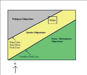
Schematic drawing of subprovinces in Voyageurs National Park
|
The metamorphic and igneous rocks reveal a history of moving lithospheric plates, ancient subduction zones, mountain building episodes, and extensive volcanic activity. The Archean (2.5-3.0 billion years ago, or Ga) rocks at Voyageurs are igneous and metamorphic rocks associated with a mountain-building episode called the Algoman Orogeny, the earliest datable orogeny in North America.
In late Archean time (2.8-2.5 Ga), repeated episodes of continental collision and north-south directed compression and subduction generated the Algoman (or Kenoran in Canada) Orogeny. During this orogeny, the Superior Craton collided with the Minnesota River Valley terrane, forming part of the Canadian Shield. Deep crustal processes transformed sedimentary deposits into dense, recrystallized, and often foliated, metamorphic rocks. This orogeny formed the gneisses, schists, especially the biotitie schist that domites the landscape, and granites exposed today in Voyageurs National Park.
Prior to the Algoman Orogeny, subduction of oceanic crust beneath the cratonic crust generated islands in the Precambrian sea. Zones of tick, basaltic lava accumulated in linear basins (backarc basins) formed between the less-dense continental crust of the Superior Craton and the volcanic islands. These lava-filled basins created today's greenstone belts. The green color of the belts comes from minerals such as chlorite, epidote, and actinolite that formed during metamorphism.
Glaciation
|
During the Ice Age in the Pleistocene Epoch, which began about 190 thousand years ago, the region experienced at least four periods of glaciation that carved the bedrock into the landscape now seen by visitors. The Archean rocks were exposed during the most recent period of glaciation, the Wisconsin Glacial Episode, which lasted from 50 thousand to 11 thousand years Bp (before present).
Because the Voyageurs area is well within the major advance of continental glaciers, where the ice was thicker and more erosive, glaciers scoured many lake basins into the underlying bedrock. These lakes were like east to west and with thousands of other lake basins in southern Canada and the United States, forming a remarkable waterway used for passage by Native Americans, voyagers, and explorers. Repeated abrasion by glacial movement has smoothed and polished many of the bedrock exposures in the park. On highly resistant exposures, glacial polish still appears glossy and fresh or slightly weathered. However, glaciers also formed glacial striations and glacial grooves, which appear as parallel, linear scratches or furrows on bedrock and erratics. Striations from from the scraping of quartz grains and hard, sharp rock fragments frozen into the bottom of the ice scratching across rock surfaces as glaciers move. Generally oriented in the direction of glacial movement, striations point south, south by southwest, and southwest in Voyageurs National Park. Glacial erratics are abundant in the Voyageurs area. These rocks of various compositions and sizes, ranging from pebbles to large boulders, were transported from the north by glaciers and deposited randomly over the landscape when the glaciers melted. Four types of glacial deposits are also found in Voyageurs: lakebed sediments, outwash gravels, peat, and till. Lakebed sediments were formed when sediments carried by the glaciers were deposited into depressions where lakes formed as the glaciers melted. Outwash gravels were deposited by the glacial meltwater outwash formed by the melting glaciers. Peat deposits formed in hollows, or depressions, such as old lake basins, bogs, and swamps. Deposits of unsorted glacial debris, or till, formed ground moraines and end moraines ( a moraine is a hill formed by glacial deposits). Ground moraine debris was deposited under the ice sheet and interspersed with lakebed sediments, forming an undulating surface known as "swell and swale" topography. End moraine till lest hummocky rides along the front, or end, of the ice sheet. |
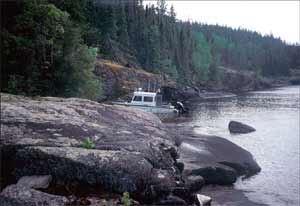
Exposed bedrock at Voyageurs National Park
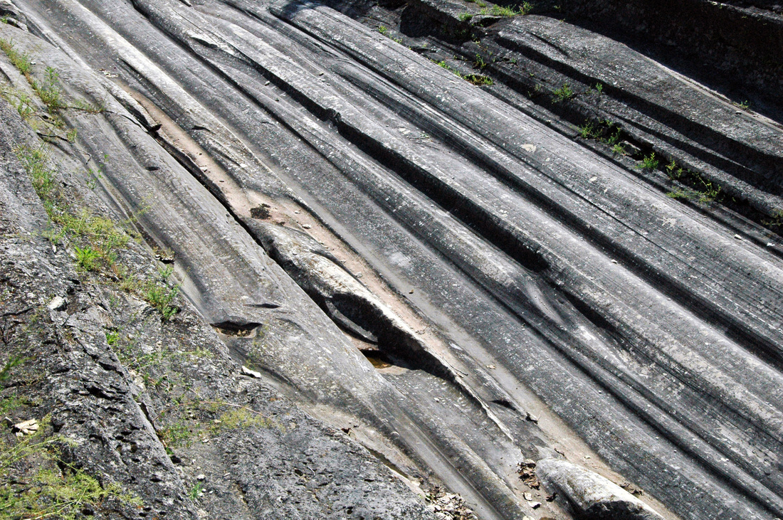
An example of glacial grooves at Grooves State Park at Kellys Island, Ohio
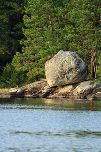
A boulder-sized glacial erratic at Crane Lake
|
Post-Glacial Period
Today, unconsolidated sediments and thin, residual soils have been superimposed on some of the oldest bedrock in North America. Due to the low relief in the area, streams have been reworking and sorting the glacial debris rather slowly. Large basins are now occupied by lakes, ponds, bogs, wetlands, and interconnecting waterways. The tremendous weight of the ice sheet depressed the crust. When the ice melted, the crust rebounded and is still rising today at a rate of about one foot per century, causing lakes and ponds to drain and bogs to form in their basins.
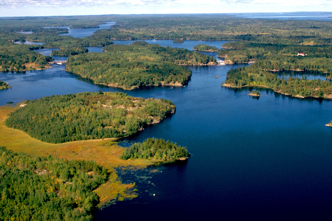
Lakes, ponds, bogs, wetlands, and interconnecting waterways now occupy large basins scooped out by the glaciers
