Hiking Trails
There are a wide variety of hiking trails that allow visitors to experience the scenic beauty of Voyageurs National Park. Trails can be short or long, easy or difficult, and there are land access trails, which are accessible by car, and water access trails, which are accessible only by boat. In addition to being used by hikers in the summer, in the winter, hiking trails can be used for cross-country skiing and snowshoeing.
Land Access
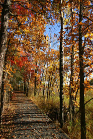 Oberholzter Trail in fall Oberholzter Trail in fall
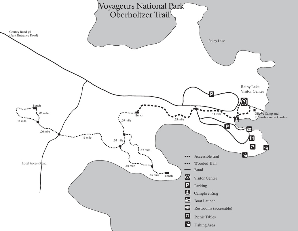
Oberholtzer Trail
Difficulty: Easy Hiking distance: 1.7 miles (round trip) Hiking time: 45 minutes (round trip) Winter use: Snowshoeing Visitors can travel from just outside the Rainy Lake Visitor Center to two overlooks to see the diversity of forest and wetland types in the park. This trail is wheelchair accessible for the first quarter mile, and pets are allowed on this trail only. |
|
|
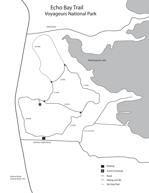
Echo Bay Trail
Difficulty: Easy Hiking distance: 2.5 miles (loop) Hiking time: 2 hours (loop) Winter use: Cross-country skiing This park trail is located three miles from the Kabetogama Lake Visitor Center off County Road 122. A wide path takes visitors from aspens to pines as it passes through lowlands ans rocky outcrops. Birding is great there, with a great blue heron rookery and sightings from warblers to woodpeckers. Sections of this trail are groomed for skiing in the winter months. |
|
|
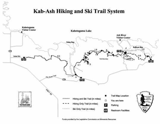
Kab-Ash Trail
Difficulty: Strenuous Hiking distance: 27.9 miles (system) Hiking time: Days (system) Winter use: Snowshoeing and cross-country skiing This trail connects the Kabetogama and Ash River communities. Visitors travel through backcountry forests and wetlands on this extreme system of interconnected trails. Four trailheads make it possible to hike sectors of this trail or the whole trail for an in-depth view of he park. |
|
|
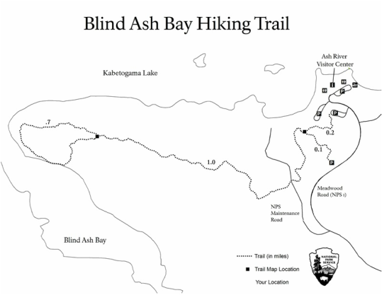
Blind Ash Bay Trail
Difficulty: Moderate Hiking distance: 2.5 miles (loop) Hiking time: 2.5 hours (loop) Winter use: Snowshoeing Visitors should park at the Kabetogama Lake Overlook near Ash River Visitor Center to access the trailhead. Visitors will travel a narrow, winding, rocky trail to experience the wonders of the boreal forest and to view spectacular scenery. |
|
|
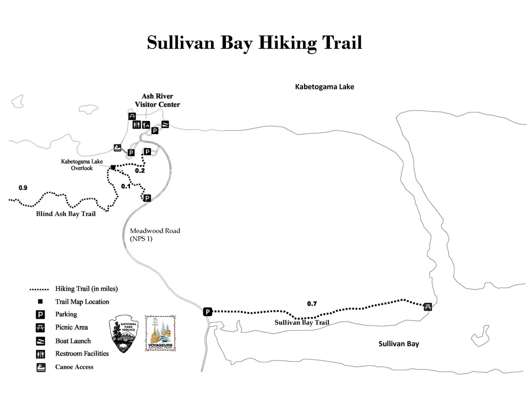
Sullivan Bay Trail
Difficulty: Easy Hiking distance: 1.5 miles (loop) Hiking time: 2 hours (loop) Winter use: Snowshoeing This is an easy hike on an old converted road, which is flat with one small hill toward the end, with a rewarding view of Sullivan Bay at the end. |
|
|
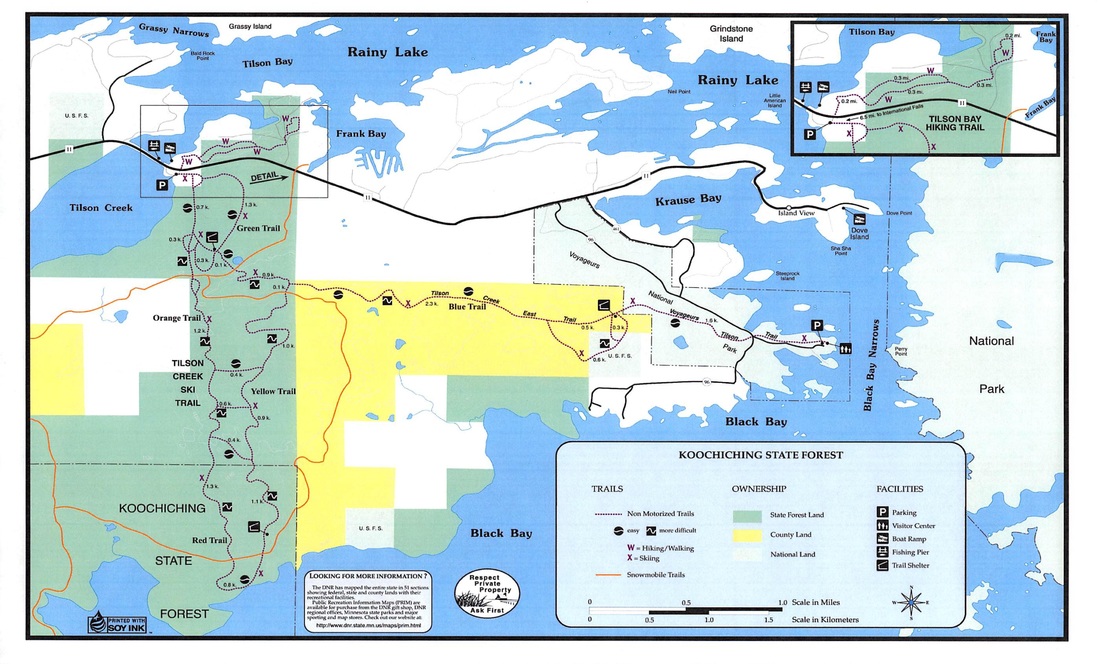
Voyageurs' Tilson Connector Ski Trail
Difficulty: Easy Skiing distance: 1 mile (one-way) Skiing time: 20 minutes (one-way) Summer use: Not maintained The Minnesota Department of Natural Resources manages this ten mile network of interconnected ski trails. Several routes are possible, ranging from short loops to longer excursions. Visitors can access this system from the Rainy Lake Visitor Center area on the park's Tilson Connector Trail. |
|
Water Access
Rainy Lake
|
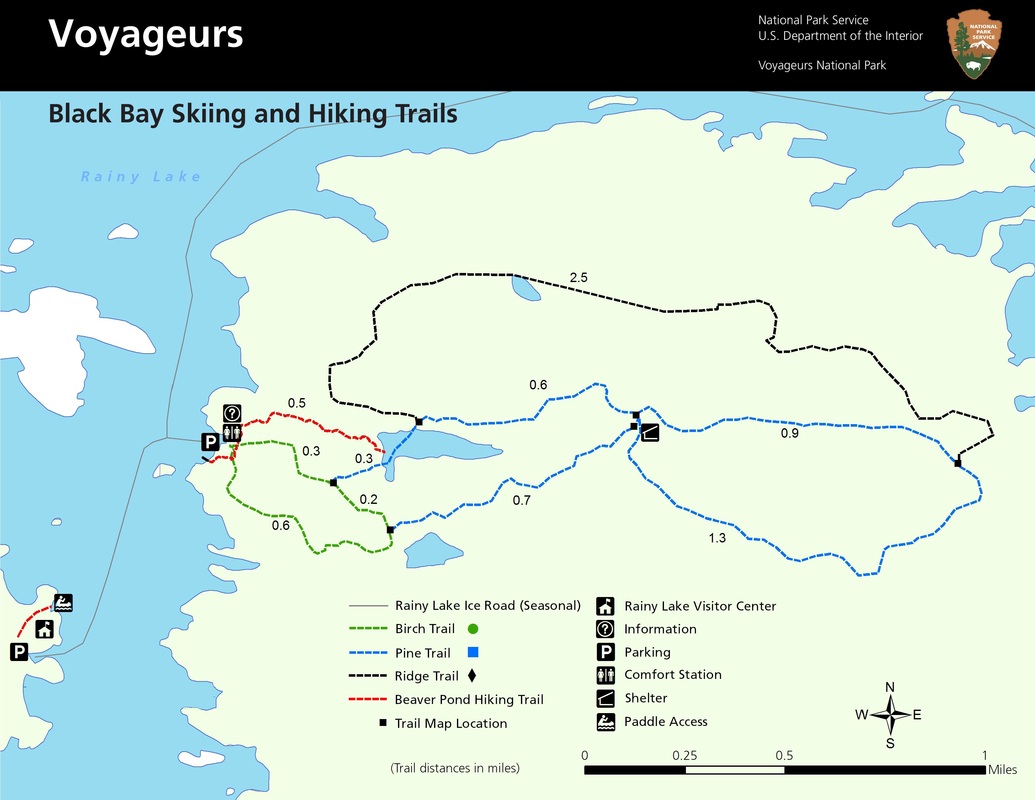
Black Bay Skiing and Hiking Trail
Difficulty: Moderate Hiking distance: 1.18 miles (round trip) Hiking time: 1 hour (round trip) Winter use: Cross-country skiing Skiing distance: 1 to 6-mile loops available Skiing time: 30 minutes to 2 hours This trail is located across Black Bay, one mile north of the Rainy Lake Visitor Center. This trail takes visitors through northern pine country to a scenic and active beaver pond. |
|
Anderson Bay Trail
Difficulty: Moderate
Hiking distance: 1.75 miles (loop)
Hiking time: 2 hours (loop)
Winter use: Not maintained
The trailhead is locate on the east end of Rainy Lake, just past the Kempton Channel. This trail takes visitors up a rocky cliff to a spectacular view of Rainy lake.
Difficulty: Moderate
Hiking distance: 1.75 miles (loop)
Hiking time: 2 hours (loop)
Winter use: Not maintained
The trailhead is locate on the east end of Rainy Lake, just past the Kempton Channel. This trail takes visitors up a rocky cliff to a spectacular view of Rainy lake.
Little American Island
Difficulty: Easy
Hiking distance: 2.5 miles (loop)
Hiking time: 20 minutes (loop)
Winter use: Not maintained
Visitors explore the past at Little American Gold Mine Island where there are mine shafts, tailings, pits, and machinery from the 1890s gold rush.
Difficulty: Easy
Hiking distance: 2.5 miles (loop)
Hiking time: 20 minutes (loop)
Winter use: Not maintained
Visitors explore the past at Little American Gold Mine Island where there are mine shafts, tailings, pits, and machinery from the 1890s gold rush.
Kabetogama Lake
|
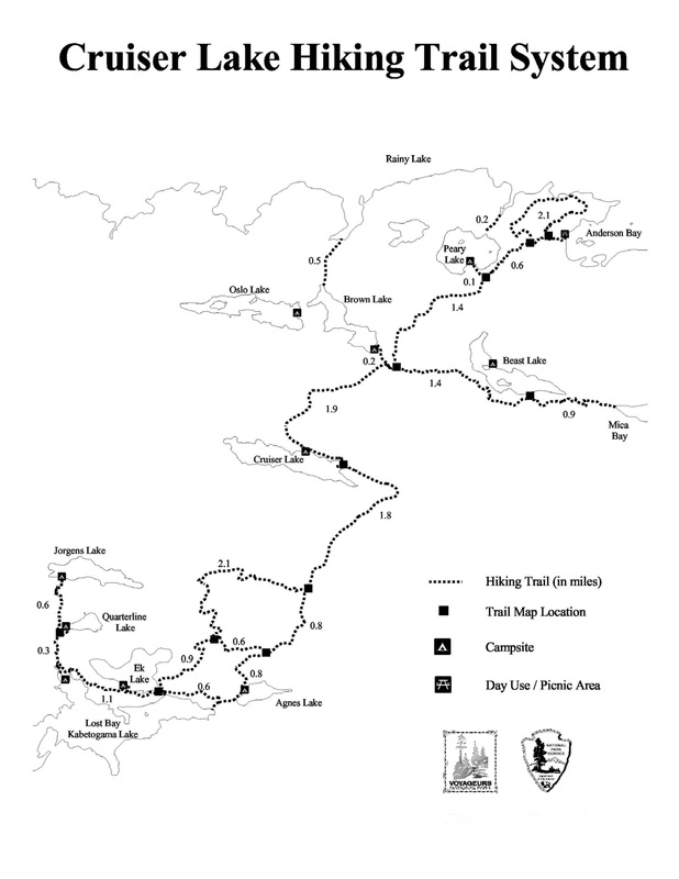
Cruiser Lake Trail
Difficulty: Strenuous Hiking distance: 9.5 miles (one-way) Hiking time: 6 to 8 hours (one-way) Winter use: Not maintained This trailhead is accessible from either the Rainy or Kabetogama areas. This trail crosses over Kabetogama Peninsula, up rocky cliffs, and down into remote wetland areas. For visitors hoping to spot some of the park's larger wildlife, taking this trail will increase their chances of spotting a moose or hearing the howl of a wolf. 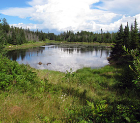
View of a small, unnamed pond from Cruiser Lake Trail
|
|
|
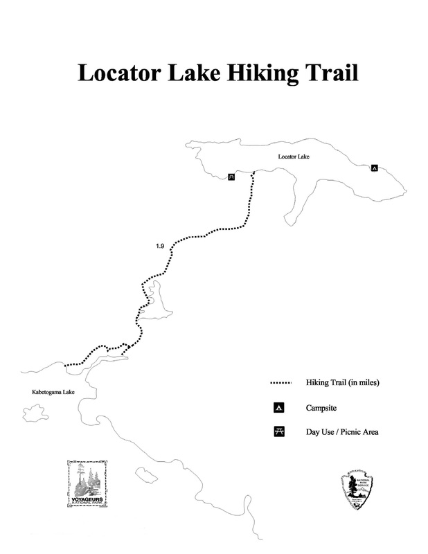
Locator Lake Trail
Difficulty: Strenuous Hiking distance: 2 miles (one-way) Hiking time: 2 hours (one-way) Winter use: Not maintained The trailhead is located across Kabetogama Lake, north of the visitor center. This trail takes visitors up and down a variety of hills through forests and wetlands. |
|
Namakan Lake
Beast Lake Trail
Difficulty: Moderate
Hiking distance: 2.5 miles (one-way)
Hiking time: 2 hours (one-way)
Winter use: Not maintained
This trail climbs the majority of the way along a ridge top. A steep climb at the beginning and at the end await more adventurous visitors.
Difficulty: Moderate
Hiking distance: 2.5 miles (one-way)
Hiking time: 2 hours (one-way)
Winter use: Not maintained
This trail climbs the majority of the way along a ridge top. A steep climb at the beginning and at the end await more adventurous visitors.
